Introduction
Since the start of Israel’s military campaign in Gaza in October 2023, Forensic Architecture has been collecting data related to attacks on civilians and civilian infrastructure by the Israeli military. Our analysis of this conduct reveals the near-total destruction of civilian life in Gaza. We have also collected and analysed evacuation orders issued by the Israeli military directing Palestinian civilians to areas of Gaza designated as ‘safe’. These orders have resulted in the repeated, large-scale displacement of the Palestinian population across Gaza, often to areas which subsequently came under attack.
The patterns we have observed concerning Israel’s military conduct in Gaza indicate a systematic and organised campaign to destroy life, conditions necessary for life, and life-sustaining infrastructure.
Forensic Architecture’s monitoring and research consists of:
- An interactive cartographic platform: ‘A Cartography of Genocide’
- An 827-page text report: ‘A spatial analysis of the Israeli military’s conduct in Gaza since October 2023’
The platform and report present a comprehensive mapping of military conduct in Gaza since 7 October 2023. They deploy spatial and pattern analysis to observe the ways in which Israel’s military operations entailed widespread civilian harm.
To identify patterns in Israel’s conduct, the platform turns thousands of datapoints into a navigable ‘map’ of Gaza, within which it is possible to define regions, periods in time, and categories of events. This filtering can reveal trends within datasets and relationships between different datasets (for instance, between the military ground invasion and the destruction of medical infrastructure).
In our analysis, we understand patterns to mean the repetition of same, similar or related incidents, at different times and places. Such patterns may indicate that these attacks are designed, formally or informally, rather than occurring at random.
Our report analyses Israeli military conduct between 7 October 2023 and 16 September 2024. It interrogates the scale and nature of attacks, the extent of damage and the number of victims, as well as the organised nature of the acts of violence and the improbability of their random occurrence.
Areas of Analysis
We collected and analysed data across six areas:
- Spatial Control – the physical shaping of Gaza according by a strategic design;
- Displacement – the repeated, forced displacement of civilians and an assessment of Israel’s ‘humanitarian measures’;
- Destruction of Agriculture and Water Resources – the destruction of fields, orchards, greenhouses, agricultural and water infrastructure;
- Destruction of Medical Infrastructure – the systematic targeting of hospitals and healthcare workers;
- Destruction of Civilian Infrastructure – the targeting of public utilities, roads, schools including those acting as shelters, religious buildings, and government buildings;
- Targeting of Aid – the systematic targeting of infrastructure and personnel necessary for the transport and distribution of humanitarian aid and the preparation of food.
Each area of analysis consists of (1) quantitative findings and (2) pattern findings.
Because military actions are multifaceted, patterns can exist across
actions. The effect of military actions on Gaza’s civilian population
may not be fully captured by studying the repetition of a single type of
action in isolation. The simultaneous, or proximate, application of
different types of action in the same territory may generate a
cumulative and compounded effect, each action aggravating the effect of
another.
By ‘layering’ multiple cartographic datasets over one another, we could:
- analyse the compounded effects of different types of acts;
- determine whether relations between different types of acts repeat across time and space;
- determine whether these relations are random or display an organised design;
- and determine the relation between military acts and the natural characteristics of Gaza by layering the mapping of these acts over meteorological and soil-type maps.
We explore these interrelations in Chapter 8: Cross-Sectional Analysis in our report.
Note:
We use the term ‘genocide’ within the meaning developed by Raphael
Lemkin, whose thinking behind this term was instrumental for the
definition formulated in Article II of the Genocide Convention.
Genocide, according to Lemkin, signifies a coordinated plan of actions
aimed at the destruction of essential foundations of the life of
national groups, with the aim of annihilating the groups themselves.
[See Raphael Lemkin, Axis Rule in Occupied Europe Laws of Occupation;
Analysis of Government; Proposals for Redress (Washington Carnegie
Endowment For International Peace, Division Of International Law 1944)
79].
> Read our summary of findings
> Read our methodology overview
Spatial Control: Summary of Findings
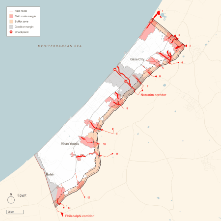
Israel has built a new system of spatial control in Gaza, re-shaping the territory by destroying agricultural lands and buildings to create infrastructure for a permanent military presence.

Quantitative findings
We have documented the following elements of Israel’s system of spatial control:
- Buffer zone: A 1km-wide zone along Gaza’s eastern perimeter, within which most buildings and all agricultural infrastructure have been destroyed.
- Netzarim corridor: A 6.5 km road with 2-3.5 km of cleared margins on its south side, and 1.7-3.5 km on its north side, bisecting Gaza north of Wadi Gaza, within which most buildings and agriculture have been destroyed
- Checkpoints: Two permanent checkpoints at the intersections of the Netzarim corridor with the main north-south arteries (Salah al-Din and al-Rashid Roads), plus four temporary checkpoints across Gaza.
- Raid routes: Thirteen routes from Israeli military bases into Gaza. The construction of these roads often involved the destruction of most buildings and agricultural lands in their path.
- Philadelphi corridor: A widened strip running east to west along Gaza’s southern border with Egypt.
We have documented the destruction and clearing of land for the establishment of the above elements:
- Total cleared land: 131.7 sq km (36% of Gaza). The buffer zone, the ‘corridors’, and the raid routes partially overlap.
- Buffer zone: 55 sq km (15% of Gaza).
- Netzarim corridor: 35 sq km (9.6% of Gaza).
- Raid routes: 62 sq km.
- Philadelphi corridor: 10.8 sq km.
Pattern Findings
- Israel’s military campaign involved the reshaping of cultivated and built environment through acts of destruction and construction. Our analysis found that these acts of destruction and construction were not haphazard, but followed consistent and clear spatial logic:
- Agricultural destruction: All farmland within these areas was destroyed. The construction of new infrastructural elements has likely contaminated the soil and inhibiting future use.
- Creating ‘zones’: The Netzarim corridor divides Gaza into two zones: a civilian-evacuated ‘north’ and a ‘south’ which includes designated ‘destination areas.’
- The Netzarim corridor and the checkpoints facilitate displacement:
- Movement between the zones is restricted and controlled by checkpoints
- Checkpoints exclusively allow southward civilian movement.
- Thirteen raid routes lead from the perimeter to the interior of Gaza.
- These routes facilitated repeated military incursions.
- The extent of work invested in their construction suggests they may have long-term presence.
Displacement: Summary of Findings
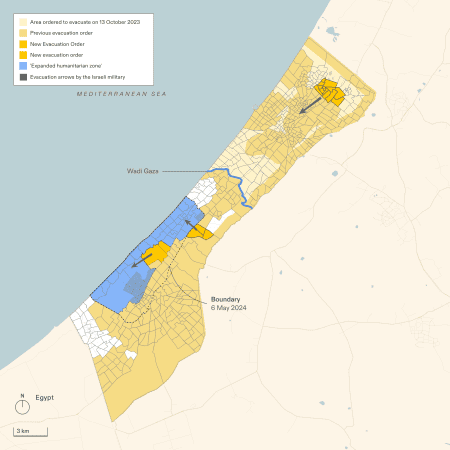
Israel weaponised ‘protective measures’ by using evacuation orders to repeatedly displace civilians to areas which were then attacked.

Quantitative Findings
- Destination areas (areas to which the Israeli military has ordered civilians to move, including the Israeli designated ‘humanitarian zone’) decreased significantly from October 2023 to August 2024, contracting from 228.2 sq km (62.5% of Gaza) to 47.4 sq km (13% of Gaza).
- On 13 October 2023, this area included all of Gaza south of Wadi Gaza and covered 228.2 sq km (62.5%) of the total territory of Gaza.
- On 7 January 2024, it included Rafah, Deir al-Balah and the al-Mawasi ‘humanitarian zone’, covering 80.7 sq km (22.1%) of Gaza.
- On 6 May 2024, it shrank to include only the newly established ‘expanded humanitarian zone’, covering 60.9 sq km (16.6%) of Gaza.
- On 16 August 2024, the ‘humanitarian zone’ contracted. The area covers 37.9 sq km (10.4%) of Gaza.
- On 30 August 2024, three blocks have been reintegrated to the ‘expanded humanitarian zone’, expanding its extent to covering 47.4 sq km (13%) of Gaza.
- The boundaries of the ‘humanitarian zone’ established from 18 October 2023 changed 9 times by 30 August 2024.
- Between 7 October 2023 and 31 August 2024, 84% of Gaza’s total area was subject to evacuation orders.
- The first evacuation order on 13 October covered 37% of Gaza.
- Between 1 December 2023 and 31 August 2024, 72% of Gaza’s total area was subject to evacuation orders.
- After December 2023, 72% of Gaza received at least one evacuation order.
- By May 2024, only 6.9% of Gaza’s territory, excluding the ‘humanitarian zone’, had not received an evacuation order.
- 66 evacuation orders were issued between 7 October 2023 and 31 August 2023. Most orders refer to multiple blocks at a time.
- 346 schools were used as shelters, 70% of which were subsequently attacked (UN data).
Pattern Findings
- The Israeli military continuously attacked all areas of Gaza: destination areas (including the ‘humanitarian zone’); Israeli designated ‘safe routes’; undefined areas (including civilian shelters); civilians from within evacuation areas.
- Destination areas have decreased in size, even as the displaced population has increased.
- The Israeli military’s use of evacuation orders has put civilians at risk by:
- Issuing inconsistent and incomplete information about the ‘humanitarian zone’.
- Issuing unclear and inconsistent evacuation orders.
- Instructing civilians to evacuate to areas that were attacked soon after.
- Issuing evacuation orders after having already begun military operations within the area in question.
- Issuing a sequence of evacuation orders that displaced civilians multiple times.
- Instructing civilians to displace to areas that had recently received evacuation orders.
- Failing to specify the duration or expiry of evacuation orders.
- Displacing civilians to destination areas that were previously targeted and destroyed.
- The Israeli military besieged displaced civilians and funnelled into checkpoints where they were surveilled.
- The Israeli military used ‘protective measures’ to displace Palestinians:
- First, civilians were directed from the north to the south of Gaza.
- Then, civilians were directed from the east to the west of Gaza.

No comments:
Post a Comment